NAUTICAL CHARTS
A nautical chart is a graphic representation of a maritime area and adjacent coastal regions. Sometimes nautical charts are not available, or very inaccurate, or available only at large scale; in this case a site survey is critical to identify the correct cage system site and orientation.
The key characteristic of the chart is that the depiction of land/sea areas is to scale, thereby providing a tool for accurate measurements of heights, depths and distances. The scale of a chart is defined as the ratio of a set distance on the map to its corresponding distance on real land/sea.
For example, on a chart with a scale of 1:100 000, each centimetre measured on the chart will be equal to 100 000 cm (or 1 000 m or 1 km) as measured on the ground.
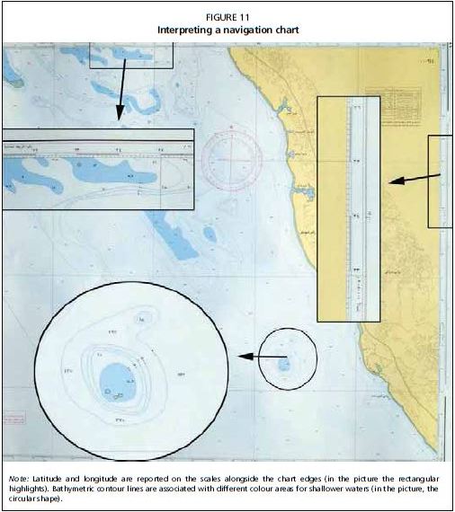
The latitude scale, which runs vertically along both sides of the chart, indicates North and South, and the longitude scale running horizontally along the top and bottom of the chart indicates East and West (Figure 11).
One of the most useful aspects of a nautical chart is the depiction of the depth and bottom characteristics through numbers, colour codes and bathymetric contour lines.
Geographical coordinates
Latitude and longitude represent the geographical coordinates, and the combination of these two components specifies the position of any location on the planet.
FIGURE 11
Interpreting a navigation chart

Note: Latitude and longitude are reported on the scales alongside the chart edges (in the picture the rectangular highlights). Bathymetric contour lines are associated with different colour areas for shallower waters (in the picture, the circular shape).
There are several formats for writing geographic coordinates, but all methods list latitude first and longitude second. The following are valid and acceptable ways to write geographic coordinates:
- DMS degrees: minutes: seconds (32° 30'00" N, 12° 30'00" E)
- DM degrees: decimal minutes (32° 30.0' N, 12° 30.0' E)
- DD decimal degrees (32.5000° N, 12.5000° E)
In the geographic positioning systems (GPS), units can be set to a specific format, but the most commonly used formats are DMS and DM. Sometimes, it is necessary to convert between these different methods of recording geographic position. There are 60 seconds in one minute, and 60 minutes in one degree. North latitude is positive (+) while South latitude is (-); East longitude is positive (+), West longitude is negative (-).