3. EGYPT
This country report was written by Soliman H. Abdel-Rahman, National Institute of Oceanography Fisheries, Alexandria City, Egypt.
3.1 Introduction
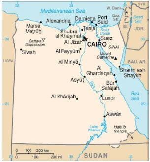
Egypt has an area of 1 000 250 km2 and a population of about 81 000 000 inhabitants (CAPMAS, 2011). Egypt is bound by Libya in the west, Sudan in the south and Israel and the Gaza strip in the east. The Egyptian Mediterranean coast is almost 1 100 km long (Fig. 1). The Nile divides the plateau across which it flows from south to north into two regions: the Western Desert and the Eastern Desert. The lower Nile Valley is a green strip across the desert, demarked by steep valley sides. North of Cairo, the valley flattens out and the river enters the delta (300 km wide, 175 km deep and about 26 000 km2 wide). The delta contains a network of irrigation canals and drainage systems.
Drainage waters finally flow into several wetlands and lagoons that face the Mediterranean Sea. These lagoons contribute significantly to the economics, environmental aspects and fishery production of the country.
Fish production in Egypt totaled 1 092 888 tonnes in 2009, of which 387 389 tonnes were coming from capture fisheries and 705 490 tonnes from aquaculture (GAFRD, 2009). Moreover, fish imports into Egypt totaled 230 000 tonnes in the same year, increasing fish consumption for humans to almost 1.3 million tonnes (CAPMAS, 2009). Fish consumption in Egypt increased from 6.4 kg per capita in 1992 to about 16 kg per capita in 2009.

Figure 1. Map of Egypt