3.2 Generalities on the coastal lagoons of Egypt
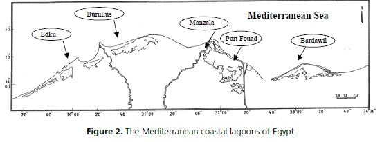
The Mediterranean coastal area of Egypt may be divided into three sectors, according to the coastal lagoons presence and typology. The western sector (west of Alexandria to Sallum) is an arid area with many tourist villages and resorts along the shore that occupy almost all the coast without any important lagoons, except for Mersa Matrouh, which is really part of the sea. The central area, from Alexandria to Port Said (Nile delta), extends for about 260 km, and contains the most important lagoons and wetlands: from west to east Edku, Burullus and Manzala.
East of Edku, there is Maryout, which has originated as a coastal lagoon, but at present can be considered as a freshwater basin as it has no connection to the sea. It is about 4 meters under sea level and receives drainage freshwater from agriculture and sewage treatment plants, which are pumped to sea by a huge pumping station. The third sector extends from Port Said to Rafah (North Sinai) and encompasses two hypersaline lagoons (Port Fouad and Bardawil) as shown in Fig. 2.

Figure 2. The Mediterranean coastal lagoons of Egypt
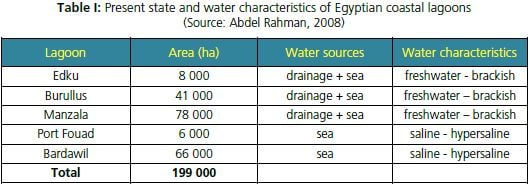
At present, Egyptian coastal lagoons cover a total area of about 200 000 ha. It is reported that some coastal lagoons of Egypt have lost about 70 percent of their total areas during the last 60 years (El Mezayn, 2010). Table I illustrates the present state and main characteristics of all Egyptian coastal lagoons.
Table I: Present state and water characteristics of Egyptian coastal lagoons
(Source: Abdel Rahman, 2008)

Main characteristics of coastal lagoons
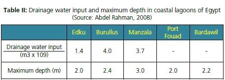
The three delta lagoons (Edku, Burullus and Manzala) have almost the same pattern of water salinity. Each of them receives large volumes of drainage water from the south (Table II) and has one or more narrow connections to the sea from the north. Freshwater enters the lagoons all year round, keeping the water level in the lagoons higher than the sea level and preventing the intrusion of seawater, except in the winter season. In winter, the freshwater flow into the lagoons is greatly reduced for the maintenance of drainage canals. All lagoons are shallow water bodies with average depth ranging between 0.8–1.0 meters.
Table II: Drainage water input and maximum depth in coastal lagoons of Egypt
(Source: Abdel Rahman, 2008)

Generally, each lagoon can be divided into three salinity zones; the southern part, with about 50-60 percent of surface area, has a salinity range between 1–3 gl-1, the middle part (about 20– 30 percent of surface) has a salinity range between 3–6 gl-1 and the north part (10–20 percent of surface) has a salinity range from 6–12 gl-1 (Shaltout and Khalil, 2005). Most fish farms are located in the southern part of the lagoons. On the other hand, no freshwater flows into the
Bardawil and Port Fouad lagoons; consequently the salinity in both lagoons ranges from 36 to 120 gl-1 depending on the distance from the sea inlet. The main site for mariculture in Egypt is located in the north-west part of the Manzala lagoon and is known as "Diba Triangular", as ithas a triangular shape of low-lying reclaimed land. This area is known in Arabic as “Mosallath El Diba”. Its total area is about 14 000 ha and its widest part is near Damietta (to the west), whereas the narrowest part is to the east (near Port Said), and bordered from the south by the Manzala lagoon and from the north by the Mediterranean Sea. Almost all farms in this area are extensive polyculture ponds using marine fish fry from the wild. Fish farmers in this area dug several canals connecting their farms with the sea allowing them to culture marine fishes such as gilthead seabream, European seabass, meagre and marine shrimp (Sadek, 2001).
Legal framework and constraints
Capture fishery and aquaculture activities in Egypt are regulated by Law 124/1983 authorizing the GAFRD to implement the acts and decrees of fish production activities. The Law 4/1994 on the protection of the environment constitutes the main legislative act in the field of environmental protection and promotion. Two coastal lagoons in Egypt were designated as Ramsar Sites.
The first lagoon is the Burullus wetland, which was declared as a natural protectorate in 1998. The protectorate includes the lake, its islets, as well as the sand bar between the Mediterranean and the lake. The lake reed beds represent one of the most important habitats in the Mediterranean,and are becoming rare and threatened. This habitat is very important for migrant birds for foraging, refuge and breeding.
The second lagoon is the Bardawil lagoon, also designated as a Ramsar Site in 1988. It is one of the least polluted lagoons in the whole Mediterranean. Very limited eco-friendly human activities are allowed in the surroundings of the lagoon. At the eastern part of the lagoon lies the Zaranik Natural Protectorate established in 1996, covering an area of 250 km2. All 7
development activities are forbidden inside the protectorate except salt production. 4
Other coastal lagoons are unprotected, apart from the Ashtum El Gamil Protected Area (declared by Prime Ministerial Decree 459/1988), which encompasses a small area (c.35 km?) located along the sandbar at Bughaz El Gamil, in the Manzala lagoon. Constrains include land reclamation, pollution and illegal fishing practices.