6. ITALY
This country report was written by Eleonora Ciccotti, University of Rome Tor Vergata, Roma, Italy.
6.1 Introduction
Italy has an extensive coastline (8 353 km), extremely diverse in morphology and pattern. The present outline of the coast has been shaped over time by geological processes combining marine and continental dynamics, such as transport of materials, erosion and sedimentation.
Among these, downstream transport by rivers has been the main process responsible for the extraordinary richness of lagoons, coastal lakes and ponds in Italy.
The present surface of lagoon areas amounts to about 167 000 ha.

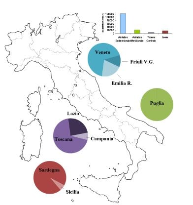
Figure 1. Coastal lagoons in Italy: surface in the four geographic areas (histogram) and relative distribution of in the nine regions (circles).
This area is a remnant of a larger extent: in pre-Roman times wetlands in Italy amounted to over three million ha (Rossi Doria and Bevilacqua, 1984). The first land and water management interventions date back to the Romans, who carried out the first reclamation interventions in the Pontine Plain (Latium) and in Tuscany (Val di Chiana, Ansedonia). In later centuries, in different moments there were other important interventions: in the twelfth and thirteenth centuries, many Benedictine monasteries were built in areas that necessitated the implementation of hydraulic works of drainage, sewerage and irrigation. Around mid-1500, the Venetian Republic reclaimed over 40 000 ha. In 1865, the Italian wetlands were reduced to 1 300 000 ha, which, however, still accounted for 4.6 percent of the total area of Italy. In the late nineteenth and early twentieth century, Italian wetlands suffered the most radical contraction, with the loss of over 1 100 000 ha. The demographic increase, the need for large areas for agriculture, but also the urgency to address malaria, which affected populations in many rural areas of the country, led to massive land reclamation, most of which was implemented in the two decades of the Fascist period. With the reclamation of the lagoon areas between Modena and Ferrara, the landscape of the lower Po valley radically changed, and most wetlands of the Maremma and the Pontine plains disappeared. Even on the coasts of southern Italy and on the islands, first of all Sardinia, large areas of coastal marshes and ponds were eradicated. In the Republican period, however, and in some cases up to the 1950s, reclamation continued through various forms of intervention on the territory.
In Italy, 198 lagoons and coastal basins are present, for a total surface of 167 575 ha. This figure arises from an inventory made for the purpose of the present project, and includes all types of coastal water bodies, such as delta branches and sacche. Ardizzone et al. (1988) reported 150 000 ha of coastal lagoon environments used for fisheries and aquaculture, 61 000 of which are effectively exploited. Lagoons are present only in nine Regions, and are concentrated in four geographic areas of the country: the northern Adriatic on the northeastern
side of the country, the south Adriatic on the southeastern side, the central Thyrrhenian on the western side and in the main islands, Sardinia and Sicilia (Fig. 1).
In the northern Adriatic, the greatest extent is present, 120 000 ha, which includes the large micro-tidal (tidal range > 0.5 m) lagoons of Venice, Caorle, Grado and Marano, along with the 45 000 ha of wetlands and valli of the Po delta. In the southern Adriatic, the lagoons of Lesina and Varano are the most important, while in the central Tyrrhenian coast there are several coastal lakes in Lazio, as well as the Orbetello lagoon in Tuscany, the largest in central Italy. In the main islands, Sicily and Sardinia, over 15 000 ha of lagoons are present, mostly located in Sardinia. These environments of central Italy are “non-tidal”, as the tidal range is less than 0.5 m.