2.2 Recommended steps
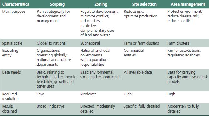
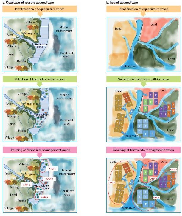
The order in which the main steps shown in Figure 1 and Table 3 are taken depends upon the local situation. For example, when aquaculture is completely new to a country or to a large geographical area, practicioners might want to start with a broad scoping exercise, followed by zoning, site selection, design of aquaculture management areas, and elaboration of the corresponding management plans. In countries or geographical areas where aquaculture farms/ structures are well established, however, it may not be possible to relocate farm/structures (e.g. ponds, tanks, raceways) to meet carrying capacity, biosecurity and socially acceptable thresholds. Under these circumstances, there may be an obligation to begin with the definition of AMAs and management plans;
TABLE 3. Main characteristics of the process for scoping, zoning, site selection and area management for aquaculture

Source: Kapetsky and Aguilar-Manjarrez (2013).
FIGURE 1. Potential steps in the spatial planning and management process for coastal, marine and inland aquaculture

Note:
• Schematic figure of a designated aquaculture zone (hatched area in blue colour) representing an estuary and the adjacent coastal marine area. Individual farms/sites (F), owned by different farmers, are presented in different colours and can incorporate different species and farming systems.
Note:
• Schematic figure of an existing aquaculture zone (the whole depicted area) representing individual land-based farms (F), e.g. catfish ponds and/or other species, that may be owned by different farmers (presented in different colours).
• The designation of AMAs depends upon mutual and exclusive use of incoming and outgoing water supplies by a given set of farmers.
The order in which the main steps are taken above depends upon the local situation.
this has been the case in countries where disease outbreaks have forced governments and producers to develop collective response protocols. In some cases, an entire zone might share a common water supply or be configured in such a way that it functions as an AMA. There is no fixed pathway; the steps are flexible and should be adapted to local/national circumstances and capacities as necessary. There are a range of different zoning, site selection and AMA schemes that have been developed worldwide to address different constraints to aquaculture sustainability and local conditions. Selected examples are described in the case studies in Annex 5.
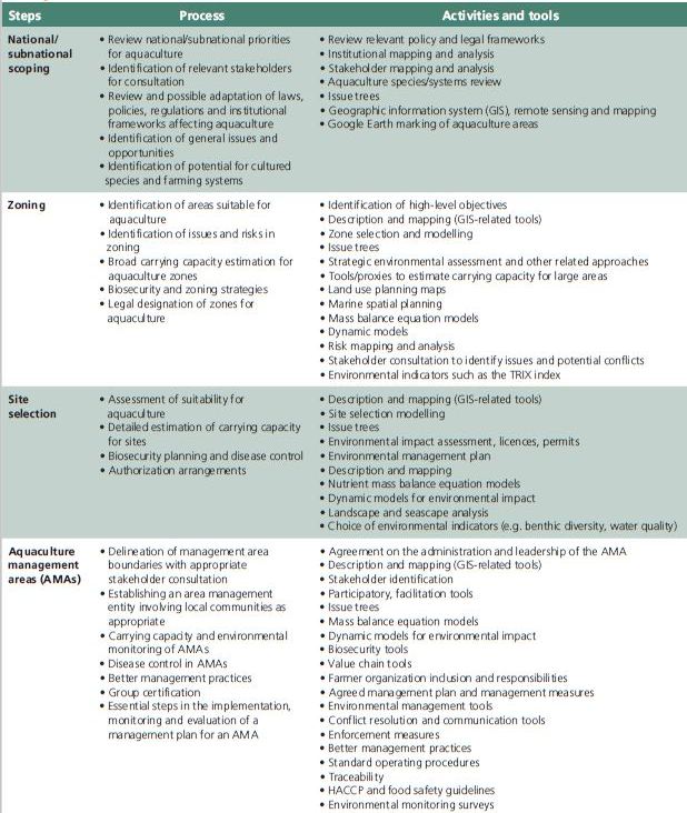
The main steps for spatial planning and area management can be broken down into a more detailed set of processes, each drawing on a range of activities and tools (Table 4). The components, and the associated activities and tools, are briefly described in the sections below. Some of the main tools and their application to aquaculture development and management are reviewed in Annex 4.
The inclusion of all these components in any planning initiative may be a formidable task. However, if the larger goal of long-term sustainable development is to be realized, most of these components will need to be considered. The outcomes of the process will also be more durable if the principles of stakeholder participation and use of best available knowledge are applied at all stages of the process.
Many of the processes and components in Table 3 are repeated in each main step defined in Table 4 (e.g. identification of issues) because each component should serve to inform the scope and focus of others steps, and because some countries may want to focus more on specific aspects without having to follow all the steps in sequence. It is recommended that countries in which aquaculture is a new activity would need to follow all the steps, broadly in sequence.
TABLE 4. Potential framework to guide the implementation of aquaculture spatial planning and area management

Notes:
• Some of the main tools and models are described in Annex 4.
• Scoping is also needed for zoning and the design of management areas.
• Ehler and Douvere (2009) describe marine spatial planning (MSP) as “a public process of analyzing and allocating the spatial and temporal distribution of human activities in marine areas to achieve ecological, economic, and social objectives that are usually specified through a political process”.
Meaden et al. (2016) provide a comprehensive listing of additional information about MSP, including worldwide examples where MSP has been applied under varied local conditions at highly variable geographic scales.

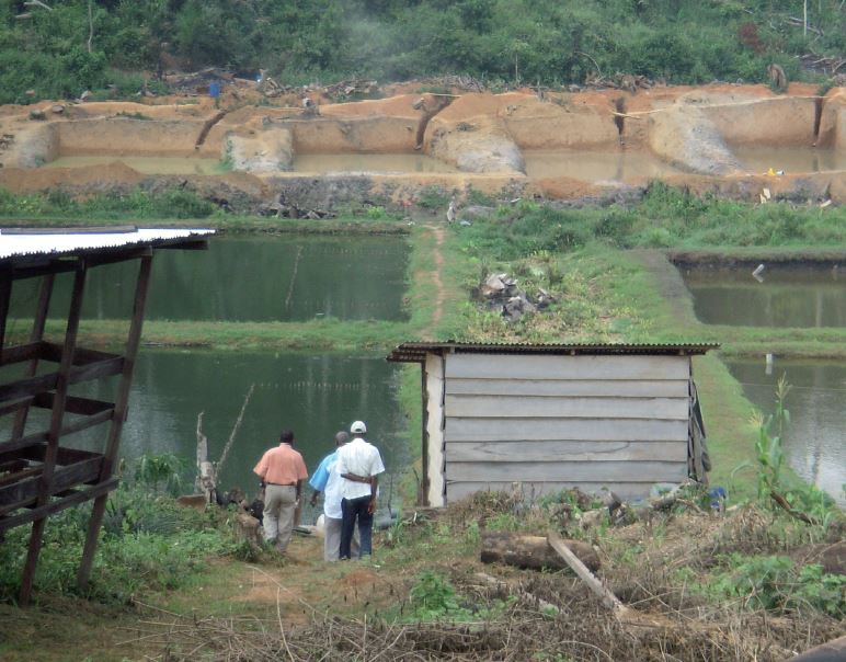
Fish ponds for culture of Nile tilapia, African catfish and African bonytongue, Cameroon
There is considerable potential to expand inland aquaculture in Africa to improve food security. The first step in aquaculture planning is identifying areas that have potential for aquaculture. In this scoping process, it is important to review any existing coastal zone management plan to establish whether it facilitates aquaculture development. Legal and regulatory frameworks should establish clear mechanisms for aquaculture zoning and site selection in waterbodies considered “common property” and the granting of tenure rights, including aquaculture licences.
Courtesy of José Aguilar-Manjarrez