2. AQUACULTURE ZONING
2.1 Scoping
At present there are four spatial territorial categories dealing with aquaculture in Chile, including sea cage farming (Figure 1):
• Appropriate Areas for Aquaculture (AAA).The areas where aquaculture (not only salmon farming) can be developed in the jurisdictional sea of Chile according
Figure 1. Spatial categories related to sea cage salmon farming in Chile. AMAs are established for the three species farmed and licenses for individualized species.

to the General Law of Fisheries and Aquaculture (Law 18,892 or GLFA, vers. 2013, Law 20,657).
An AAA includes Macro zones, Neighbourhoods and farming sites (also mentioned as Licenses or Concessions).
• Macro zones (MZ). Zones defined by the Authority (SUBPESCA) to avoid dispersion of a given disease or infection in any farmed species that have created an emergency situation. (GLFA, D.S. 391, 2001). Macro zones include AMAs (Neighbourhoods) and farming sites or licenses.
• Aquaculture Management Areas (AMAs); Also named Salmonid groups of licenses or Neighbourhoods (NEI). Group of aquaculture concessions within an AAA situated in a sector that presents safety, epidemiological, oceanographic, operational or geographical features that justify its coordinated sanitary management by species group (for instance salmonid species), as per SUBPESCA declaration (LGPA, vers. 2013). Neighbourhoods include farming sites or licenses.
• Farming Sites (Licenses or concessions, LI). The administrative act through which the National Ministry of Defense gives to a person/entity rights of use of a resource (water column, sea bottom, coastal site, etc.), for a period of 25 years renewable, to carry out in them aquaculture activities (GLFA, vers. 2013).
The National Policy of the Coastal zone dictates that Coastal Plans have to be established in coastal regions of the country defining zones of preferential uses (Figure 1).
Sea cage farming in sea water in the country is just practiced for salmon species, i.e:
• Atlantic salmon (Salmo salar)
• Rainbow trout (Oncorhynchus mykiss)
• Coho salmon (Oncorhynchus kisutch)
AAA evolution. AAA were established in the 1991 General Law of Fisheries and Aquaculture (GLFA) as areas situated under public use where aquaculture can be developed prior to consultation with relevant organizations in charge of alternative uses for those spaces. According to the current Law, AAAs are not exclusive, because other activities noninterfering with aquaculture can be developed within them like tourism and benthic resource management areas, among others (FAO, 2012; García, 2013).
Immediately after enactment of the GLFA in 1991, the Chilean Government, through SUBPESCA, initiated the process to establish the AAA in the country giving priority to the regions where aquaculture was initiated.
Process and consultation. Under the Law, it is the responsibility of the SUBPESCA to develop technical studies for identifying appropriate areas for the exercise of aquaculture, consulting with agencies responsible for alternative uses of those areas over water or land, and considering especially the existence of aquatic resources or conditions for their production and protection of their environment. These studies should also consider artisanal fishing activities and related communities, mining and communities, exit and entrance tracks to ports, anchoring areas and areas for practice of the national Navy ships, areas of ports development and touristic attractions. Also AAA cannot be established over fishing grounds established according to the Law. AAA should also be excluded of natural banks of benthic resources and algae beds. On the other hand, intensive or extensive farming of exotic species must keep a minimum distance of 1.5 nautical miles from marine parks and marine reserves. In cases where the land protected areas have their limits with the sea, a protection marine band will preclude the development of intensive or extensive aquaculture based in exotic species. Once studies conclude, SUBPESCA must publish in the official newspaper and in another one of the involved region the proposed AAA. Within 60 days from the publication individuals or institutions can express their opinions (written) on the studies. In such case, the SUBPESCA shall respond to stakeholders within 60 days. Final proposal and studies must be sent to the Ministry of Defense. Final decrees will have to approve the AAA specifying their perimeter. The process is schematized in Figure 2.
Since the beginning (1991) the AAA establishment was a participative process under which the officials of the SUBPESCA visited the regions organizing meetings with local authorities, farmers, scientists, interest
Figure 2. Process to establish AAA in Chile.

groups, and the Navy, among the principal ones.
The authority presented their initial studies and ideas about the AAA envisaged which served as a base of discussion. The definitions were strongly influenced by the current production technology in all ambits of marine aquaculture and by the purpose of operating farms in areas well protected of adverse environmental conditions, essentially winds and waves. Also the logistic factors were considered based on the current installations as those expected as per the geographic characteristics of the coast.
Based in the above presented process the Authority published the AAA and received public observations that were finally considered before the final Decree of the Ministry of Defense. In 1991–1992, essentially the predominant sea aquaculture activities were salmon, trout, red seaweed and mussel farming in the Los Lagos Region and scallop farming in the Atacama and Coquimbo regions. Those were the prioritized regions to establish AAA.
At present 12 of 15 regions of Chile have AAA. Still pending: the regions Arica—Parinacota (XV) and Valparaíso (V). Metropolitan Region (XIII, RM in map) do not have coast. A summary can be seen in Figure 3.
Legal, regulatory and institutional frameworks.
The Law 19,800 (2002) of the Agriculture Ministry modified the article 158 of the GLFA (Law 18,892).
With this change, lakes, rivers and maritime zones forming part of the National System of Protected Wildlife Areas are excluded from all extractive aquaculture and fisheries activities. However, in the Maritime zones that are part of the National reserves zones these activities can be developed with previous authorization of the competent agencies, to complement maritime activities of aquaculture.
The coastal zoning in Chile is the process of management and planning of the coastal spaces, in order to define the territory and establish its multiple uses, expressed in preferred applications that will not be exclusive, except in cases of use incompatibilities with specific activities determined in defined sectors of the same zoning plan. The zoning plan identifies specific zones, limits, conditions and restrictions for administration in accordance with the provisions of the National Policy on the use of the coastal zone. According to this regulation if in a given region coastal zoning has been established and duly published, the AAA should be amended to be compatible with this zoning. From the date of publication of the decree establishing zoning no new aquaculture concessions will be granted in sectors that have been defined not consistent with that activity (Silva, 2010). In cases where SUBPESCA proposes suitable areas for aquaculture, the Regional Commission of the coastal zone must analyze and respond within six months counted from the time of requirement.
Figure 3. All regions of Chile have AAA, except XV, V and Metropolitan (RM). X region is closed for new licenses.
. X region is closed for new licenses.")
Development context. During the last 2 years the AAA has been questioned principally by the salmon industry that has demanded a review that can facilitate site relocations and reduction of site concentration.
On the other hand, different actors have mentioned the convenience to adapt them to the need of moving the sites gradually towards more exposed or oceanic places releasing the coastal zones for other activities like artisanal fisheries, mussel and small-scale farming, and tourism among others. This was pointed out as early as 1996 (Alvial and Reculé, 1996).
In 2005 several studies evidenced the limitations of AAA boundaries established 10 years before without oceanographic and environmental studies for each zone. As a result some areas were declared appropriate when in reality they were not (Aldayuz, 2005).
Authorities and the private sector have included this important topic in the agenda to review the system and introduce in the future complements or modifications. The former President of SalmonChile A.G. (the Chilean salmon industry association), C. Barros, pointed out that territorially AAAs accomplished their original objective to spatially order the activity, “but technologies changed through time making feasible farming in more exposed areas of the sea; however the system did not adapt to the new changes and new aquaculture developments. As a consequence the system moved from a positive tool ordering the activity to a serious constraint that tended to concentrate farms” (García, 2013). For other leaders, like Julio Traub, “the AAA’s more than appropriate areas for aquaculture should be considered ‘authorized areas’ because in its creation the system did not limit other activities in them and just permitted aquaculture respecting distances between farms.” These present objections are also shared by mussel producers who estimated through one of their leaders, Eugenio Yokota, that the AAA establishment was a very fast procedure with no adequate consultation process.
AMICHILE, the biggest association of mussel farmers, also considers that any eventual review has to consider water body capacities before approving future changes (García, 2013).
For the author of this paper, cited in the same publication, the review of the AAA should be based on the best available environmental and oceanographic information, and should consider a displacement of salmon farming sites toward more oceanic waters releasing coastal sites for artisanal fisheries, mussel and seaweed farming, minimizing saturation and conflicts close to the coast.
Main socioeconomic, environmental, biosecurity and governance issues and factors. The AAA system was established in order to regulate use of aquaculture of the space in the coastal zone. This need was principally evident in the X Region (essentially Puerto Montt and Chiloé areas) where a gradual concentration of salmon and mussel farming sites became evident as interfering with other users. The scallop farming in the northern regions, IV and III experienced a similar but less intensive situation.
AAA represented the very first zoning effort of an economic activity in the Chilean Sea. Not being in the context of a wider multi-sector system, the risk was from the beginning of potential conflicts of AAA with other users in the future, and it finally has happened.
In fact, the national use of the coastal zone policy was enacted years after the AAA was established.
Consequently, when the regions having AAA faced the process to define a management plan of coastal zoning, the conflict emerged to conciliate other uses like artisanal fisheries, natural reservations, tourism, etc., with the already established AAA.
In summary it is possible to say that originally the AAA’s definition was essentially based on environmental aptitude of coastal zones for sea farming (emphasizing protection of bad weather conditions) and almost not considering oceanographic and environmental knowledge which requires a review of AAAs.
During past years several modifications to the original limits of the AAA have been introduced in the different regions. More recently modifications have been done to adjust them to regional coastal zone plans.
Through the Law 20.434 (2010) was introduced the option to declare AAA for group of species. The same Law closed new license applications in the X Region except for seaweed farming; it closed temporarily, for 2 years licenses for salmon species farming in the XI Region and also temporarily closed applications in the XII Region until the modification of the AAA for group of species in the period of 12 months.
In 2012, due to the high farm concentration in the X Region, particularly of salmon and mussel, the Sub Secretary of fisheries declared the AAA of the X Region not available for new license requests, the only exemption being seaweed farming (R.EX. 825—2012, under Secretary of Fisheries and aquaculture). This fact will strongly reinforce the observed tendency showing an increase of licenses and salmon operations in the XI and XII Regions. In fact, at present the XI Region is leading farmed salmon harvest in Chile.
Risk assessment analysis has not been explicitly included within the elements considered by the authority in the definition of the AAA. This aspect has been part of the discussion in the meetings and workshops when other agencies and users are included in the consultation process.
2.2 Zoning Process
The process. The first Fisheries Law enacted in 1991, established the AAA. The same Law indicated the general procedure to establish them. Then the Under Secretary of Fisheries leaded an initial proposal and developed a consultation process, including committees in regions and headquarters in Valparaiso, to prepare the first AAAs. Priority was given to regions with existing aquaculture operations like: Coquimbo (IV) and Los Lagos (X). The final proposal was presented to the National Fisheries Council, the Under Secretary, The Defense Minister (Navy) and the Minister of Economy.
Choosing the tools for spatial planning. Charts initially used in the 80s were those managed by the
Oceanographic Service of the Chilean Navy (SHOA) that became obsolete. The same procedure was used in defining location of licenses. Positioning was done in active cooperation with the Navy. Late in the 90s a geo referential unit was created in SUBPESCA to manage spatial aspects of licenses and zones. The approving decrees were spatially referred to in the original charts.
Problems associated with new licenses positioning revealed deficiencies of the old system applied causing conflicts between aquaculture users and between them and other users of the coastal zone. That situation determined the need to regularize sites and zones adjusting their location and boundaries introducing a modern and widely applied digital cartography WSG-84 system, scale 1:50,000. This process initiated long ago in the past decade has progressed in the different regions demanding very exhaustive analysis and adjustments. This approach has allowed the use of Geographic Information systems (GIS) and Geographic positioning systems (GPS) facilitating use by the authority, companies and general public. Regularization started with the complex X Region and it was followed by the XI and XII Regions. All of them were related to sea salmon farming. Then regularization continued in the other regions. The new system has expedited procedures connected to zones and license approvals and modifications.
The new charts are published in the SUBPESCA web site, in section: “Áreas apropiadas para el ejercicio de la acuicultura (AAA),” link www.SUBPESCA.cl/ institucional/602/w3-propertyvalue-50829.html, and then under Cartografía digital de AAA (Digital cartography of AAA), and Información georeferenciada, where AAAs may be seen for all regions. An example is shown in Figure 4.
The execution of the technical studies has been in charge of specialized consultants selected through public selection processes. They have obtained photogrammetric surveys of the coastal zone situating on them the concessions now positioned with high precision (Aldayuz, 2005).
Zoning application. AAAs have been applied in all regions except the three ones mentioned above.
In all cases legal process and procedures have been strictly respected, allowing public participation. New knowledge and demands for the use of the coastal zone by other sectors, as well as the adjustments necessary in light of the coastal zoning plan defined
Figure 4. Part of the AAA in the X Region using the digital cartography system of SUBPESCA.

Table 1. AAA’s surface in hectares per region and total. Only salmon sea farming regions are considered.
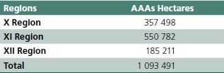
by regions, have motivated modification of the AAAs approved through decrees explained in the SUBPESCA web site www.SUBPESCA.cl/institucional/602/w3-propertyvalue-50861.html. Presently 12 of 15 regions of the country have AAA’s approved, a summary of the total surface covered by them by region and total is specified in Table 1.
Sectorial planning. AAAs have been integrated in the context of the coastal zone management plan established in different regions. In fact, the regional plans recognized different zones of preferential use (National Commission of the coastal zone use, www .ssffaa.cl/comision-nacional-de-uso-del-bordecostero- cnubc/), like:
• Appropriated Areas for Aquaculture (AAA)
• Management and exploitation areas of benthic resources
• Distribution areas of the main national fisheries
• Protected marine areas
• Vulnerable marine ecosystems
• Coastal spaces of originary people
• Free access areas Ref.: www.SUBPESCA.cl/ institucional/602/w3-article-60648.html
An example of the coastal zoning is shown in Figure 5 (Aysen Region). A complete detailed mapping with all coastal zoning plans in the Chilean regions can be found in “Geoportal de Chile: www.geoportal .cl/geoportal/catalog/data/uso-de-borde-costero/ zonificacion-de-uso-de-borde-costero.html as part of the web site “IEDE Chile—CatálogoNacional de InformaciónGeoespacial” (IEDE—Chile—National Catalog of geo spatial information).
Estimation of aquaculture potential. Based in the use of AAAs in the three regions where sea cage farming is practiced (X, XI and XII), considering present regulation, production technologies, neighbourhoods rotation programs and that the X Region is closed for new licenses, an estimate of total maximum salmon production is around 1,5 to 2 million tonnes.
Selecting the optimal zones for aquaculture. As was mentioned above, originally the AAAs definition was essentially based in environmental aptitude of coastal zones for sea farming (emphasizing protection of bad weather conditions) and almost not considering oceanographic and environmental knowledge which requires a review of AAAs. Then a review of restrictions was applied to make necessary adjustments.
These restrictions were essentially in: port influence areas, fishing zones, known breeding and spawning zones of marine species, navigation tracks and ships mooring zones, strategic areas reserved for the navy, natural reservation zones, zones that should be protected and/or reserved according to contributions of the participants in the different committees from regions and Valparaíso involved in the process, like endangered habitats, and areas of potential value for tourism among others.
However the technological evolution of aquaculture, its expansion, the emergence of some conflicts with other users of the coastal zone, and the emergence of coastal zoning in some regions, determined that AAA had to be part of the map of preferential uses zones and adjust to the new specifications for any new license in the future. This fact caused some concern in the salmon sector (Silva, 2010) because in their opinion this opens uncertainty for the future of the activity.
Lessons learned from recent ISA (Infectious Salmon Anemia) crisis and the evidence of high concentration of farms in sensitive areas have determined some changes in regulation that allow modifications of AAA, limit new licenses in determined AAA and accept eventual relocations of licenses within a given AAA.
Figure 5. Example of coastal plan zoning (Aysen region). Aquaculture preferential use zones in dark pink (taken from Zúñiga, 2013).
. Aquaculture preferential use zones in dark pink (taken from Zúñiga, 2013).")
Any eventual AAA considered should be part of the coastal zone management plan of the pertinent region following the evaluation of the regional Commission of the Coastal Zone and then the final approval of the National commission. The commissions are integrated by representatives of different sectors dealing with: the aquaculture industry, other economic sectors, indigenous people (Law 20249, 2008, creates marine space of original people), local communities, regulation and enforcement authorities, research institutions and NGOs related to environmental and social protection.
They assure that consideration is given to several potential impacts, like: environmental and biosecurity problems for the industry, regulation and enforcement prohibitions/constraints, conflicts or not desirable effects on other users, indigenous people zones, neighbourhood communities, risk of impacts on ecosystem, endangered species, natural reservations and sensitive zones, among others.
Risk mapping. After an initial long period in which risk analysis was only applied in the aquaculture industry by few companies and R&D institutions, like Marine Harvest—Chile (where the author was Technical Director), after the ISA crisis more private companies and the public sector introduced risk analysis.
In fact, presently authorities, associations, technological institutions and R&D entities are regularly applying in their analysis decision making processes holistic risk analysis methods. In general they proceed through expert consultants principally in the areas of epidemiology, environmental assessment and biosecurity (José M. Burgos, Former National Director of Aquaculture, SERNAPESCA, personal communication).
Examples of these risk analyses are: epidemiologic studies for new regulations and site management in farm companies; and epidemiologic, biosecurity and risk analysis dealing with navigation track definitions in the macro zone of salmon farming, principally financed through the Fishery Research Fund—Aquaculture—that depends on SUBPESCA.