2 Aquaculture Zoning
According to aquaculture by-laws, a site should not be installed near any sensitive environmental areas or in sites that contradict with fishermen activities or a navigational route in the sea (MAF, 2012). However, there is no detailed specification in the by-laws regarding the site selection, size or criteria of the site required for each type of aquaculture. The land will be rented for the company and renewed annually.
2.1 Site Selection Project
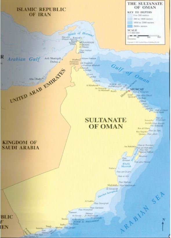
Determination of suitable sites for aquaculture is very important for the success of the commercial aquaculture projects. This selection is based on many criteria and factors that should be considered before selecting the site. Therefore, the Ministry of Agriculture & Fisheries conducted a detailed survey of the Omani coast at the beginning of the last decade (Al-Yahyai et al., 2004). This survey was concentrated mainly on the land to select the suitable sites for land aquaculture. Oman is located in the southeast corner of the Arabian Peninsula. It has more than 3165 km of coast from Musandam in the north to Salalah in the south which faces three seas: Arabian Gulf, Gulf of Oman and Arabian Sea (Figure 2). Oman has 11 Governorates with 8 coastal ones. These coastal regions include Musandam, North and South Al-Batinah, Muscat, South Al-Sharqiuah, Al-Wusta and Dhofar.
Each of these regions has its special morphological characteristics.
The total area of Oman is about 309,500 km2 that contains the mainland and some islands such as Masirah and Al-Halaniyat islands. Oman has about 11 topographical areas such as (Anonymous, 1990):
1. Mountain.
2. Mountain and plateaus affected by monsoons.
3. Dissected rocky plateau.
4. Accumulation plain.
5. Accumulation/denudation plains.
6. Coastal alluvial plain.
7. Sabkha and dunes.
8. Nearly level pediplains.
9. Gently undulating pediplain.
10. Umm As-Samim sabkha.
11. Sand dune areas.
There are two coastal alluvial plains in Oman, one in the Al-Batinah region and the other in Salalah. These plains were formed from the deposition of wadis, mainly fine sand and granules. Sabkha areas appear dominantly in the Al-Wusta region and Eastern coastal plain in the Sharquiah region.
Each coastal governorate was visited twice to collect the necessary information. This information included location, water quality, soil type, topography, accessibility, soil and infrastructure, etc. Maps, description and photographs for each area were produced. On the basis of this information, site identification and evaluation were made. In addition to the field data, available information from different governmental authorities was also collected.
Each region in Oman has its special features that allow some types of aquaculture and not the others.
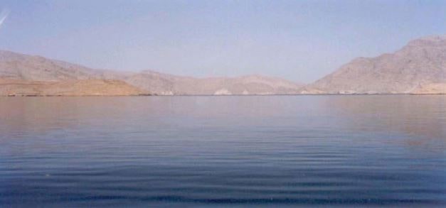
Musandam Governorate in the North of Oman is more suitable for cage culture projects or other marine aquaculture projects such as shellfish or seaweed
Figure 2. General map of Oman.

Figure 3. One of the protected lagoons (fjord-like) in Musandam suitable for marine cage aquaculture.

culture (Figure 3). This is due to the availability of the deeper khawrs (fjord-like). On the other hand, this area is not suitable for land-based aquaculture due to the lack of the suitable large site along the coast.
Al-Batinah Governorate is a heavily dense population area along the coast. For this reason and also due to the major infrastructure projects along this coast such as water desalination plants, harbors and the major coastal road, there are no available sites for land aquaculture. For marine projects, there are possibilities for cage culture, but they should be located more inside the sea due to the low depth of the coastal area which extends for a big distance inside the sea, and also for the major fishermen activities. This area is more suitable also for integrated tilapia aquaculture as it is one of the best agriculture lands in Oman.
Muscat Governorate is the capital of the country in which most of the development is concentrated.
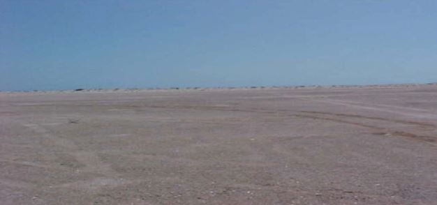
Therefore, availability of the free land for land aquaculture is very low or absent compared to other regions. There are few places suitable for cage culture in Muscat and one site was already utilized before for European sea bream cage culture. Al-Sharqiuah and Al-Wusta Governorates which face the Arabian Sea are among the best places for land aquaculture in Oman, especially for shrimp culture. These two regions include many large sites with suitable soil types that are not suitable for any other commercial projects (Figure 4). Cage culture may not be suitable due to the very rough sea during the summer. In the south of Oman (Dhofar region), there are many suitable sites for abalone indoor culture. Cage culture in this region is difficult due to the monsoon effects and very high seas during the summer.
Marine sites in other regions rather than Musandam were not included in this survey as time and resources were limited.
2.2 Atlas for Suitable Site for Aquaculture and Zoning Process
This atlas is considered as a most comprehensive publication for suitable sites in Oman for aquaculture (MAF, 2010). Preparation of this atlas was based on the result of a previous survey and also more studies from the consultant company which prepared the atlas. The consultant company used satellite images, physical data and environmental data (soil and water parameters) for preparations of this atlas. The atlas contains general oceanographic and environmental descriptions about the coast of Oman. It also contains
Figure 4. Large subkha area suitable for shrimp aquaculture.

general information about the suitable methods for aquaculture and major constraints. The main part of the atlas discusses the physical and environmental characteristics of different regions in Oman. The atlas divides the coast into 7 regions, region I: Rakhyut to Sawqrah; region II: Sawqrah to Madrakah; region III: Gulf of Masirah; region IV: Masirah to Ras Al Hadd; region V: Ras Al Hadd to Muscat; region VI: Muscat to Shinas and region VII: Musandam.
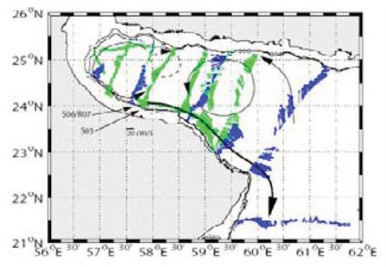
For each region, there is a detailed description about oceanographic characteristics such as weather, wind conditions, bathymetry, regional circulation of currents (Figure 5), tides, sea surface temperature, phytoplankton, sea surface salinity, and waves. It also includes descriptions about environment of the region and environmental constraints that may affect the aquaculture projects such as seagrass and algae, mangrove, marine turtle, coastal birds, and coastal protected areas. Samples of seawater were also taken from determined sites in each region and a description of the results was included in the atlas. Soil samples were also taken from some of the sites and analysis was presented with advice for suitability for shrimp pond culture or not. General information about ports available in the regions was also presented with the facilities available in these ports that can be used for aquaculture. In each region, there is also a description about the aquaculture potential and the suitable type of aquaculture that can be conducted in the region.
Finally, there is also a cartographic illustration for each region.
Despite the wide information about the whole coast of Oman and suitability of each region for different types of aquaculture, there is no detailed information about suitable sites for aquaculture such as size, cultured species and carrying capacity for the site for both land and sea areas. In general, this atlas is a good initial step in aquaculture zoning in Oman and it can be the base for more detailed study about each region.
2.3 Site Allocation Process for Aquaculture
As a result of the survey and the atlas study, suitable sites for aquaculture were determined by the Ministry of Agriculture & Fisheries and sent to the Ministry of Housing to allocate the sites for aquaculture. Ministry of Housing is the competent authority in Oman for sites allocations for all purposes. The information about the sites including name, coordinates and size required is sent to the Ministry of Housing which reviews the information, and if the site is not allocated
Figure 5. General circulation in the Sea of Oman (MAF, 2010).

for any other purpose, the subject will be forwarded to the local administration branch of the Ministry of Housing where the site is located. The reason behind this is to review the issue with the local people to eliminate any contradictions in the interests of local people. After that, the approval is given for the site.
Then, the issue is sent to the Ministry of Environment & Climate affairs for the environmental approval for the site. This is to assure that the site is not in any natural protected areas or there are no natural sensitive areas such as coral reefs, seagrass, mangrove, etc. If the environmental approval is given, the site is allocated for the Ministry of Agriculture & Fisheries for aquaculture purposes. For sea sites, the same process is also applied. The Ministry of Transport & Communication is also involved in sea sites as it is responsible for navigation routes. Local people are consulted for the sea sites through a local committee which includes representatives of fishermen. This committee ensures that the cage structures or any other types of marine aquaculture don’t affect their fishing activities.
The site will be opened for investors through a public advertisement. All the applications are evaluated technically and financially by an aquaculture technical committee. The recommendations of this committee are raised to the main aquaculture committee for a final decision.
2.4 S electing Suitable Site for Marine Cage Aquaculture in Musandam Governorate– GIS-Based Approach
The importance of GIS in aquaculture is increasing and it is used widely in several countries in the process of aquaculture management and development (Aguilar-Manjarrez et al., 2010). Spatial planning is an important element in the process of applying ecosystem based management in aquaculture. In Oman, most of the use of remote sensing and mapping was in fisheries. These tools have been used to monitor the movement of commercial fishing vessels as these vessels have predefined areas in which to catch. A survey for fish stocks assessment in the Arabian sea coasts of Oman used also these tools to provide spatial information that can be used in the management of the important commercial marine species in these areas. In aquaculture, the previously mentioned book “Atlas of Suitable Sites for Aquaculture Projects in the Sultanate of Oman” used maps and spatial data for mapping of aquaculture sites and to select of suitable site for aquaculture.
Using GIS models is being recognized as a tool for aquaculture, but this use was faced by many obstacles such as lack of appreciation of the benefits of GIS, inadequate administrative support, limited understanding of GIS principles and associated methodologies (Nath et al., 2000). Realizing the importance of GIS and spatial tools in aquaculture management, the Aquaculture Development Directorate initiated in September 2014 a project entitled “Sustainable Development of Fisheries & Aquaculture in Musandam Governorate—A GIS-Based Approached” with the financial support from Agriculture & Fisheries Development Fund (AFDF). The main aim of this project which will be for 2.5 years was to evaluate all the factors that affected the selection of suitable sites for aquaculture and also to determine the carrying capacity of each site using GIS tools. The study area which is located at the North of Oman is considered as the main area in Oman for cage culture due to the availability of large deep protected lagoons (fjord-like). This project will also take into consideration some fisheries aspects such as fish landing places and fisheries activities in the study area. The objectives of this project include:
1. Identify suitable generic areas for aquaculture development in Musandam Governorate.
2. Identify and assess the key biophysical and socioeconomical industry related factors affecting the development of commercial aquaculture in the Governorate.
3. Identify suitable species for culture according to local conditions and requirements.
4. Define carrying capacities of khawrs (fjords) according to local conditions.
5. Determine efficient strategies through resource assessment and management for suitable site selection decision making.
6. Identify all fishing landing sites and beach purse seining sites in addition to the sites of supporting activities such as fish drying and fish processing plants using GIS models.
7. Build up a model for sustainable aquaculture development applicable to other regions of the Sultanate of Oman.
In general, we expect a better understanding of the dynamic of marine environment in the study area and information that helps decision makers to better determine and allocate sites for aquaculture, taking into consideration all the environmental, socioeconomical and biological factors. The main expected outcomes from this project are:
• To advance the knowledge and understanding of key biophysical and socioeconomic factors affecting the development of the aquaculture industry.
• To define effective strategies through resource assessment and management for efficient decision making on suitable site selection for development.
• To identify suitable species and technologies for culture according to the conditions defined.
• To develop an integrative methodology for site selection of aquaculture opportunities within the Musandam Governorate that combines spatial factors and criteria (water quality, currents, depth, sediment quality and ecological quality) to identify suitable areas using GIS tools, and explores production, socioeconomic outputs and environmental impacts by applying farm-scale carrying capacity modelling specie-specific.
• To define the suitable fish landing sites and beach purse seining places.
• To make management recommendations, in order to exemplify the use of this approach to assist the decision making process and reduce socioeconomic and environmental problems associated with aquaculture expansion.
This study includes three stages of works. The first stage is for a literature review which includes collecting all the available information about the study area and also about using GIS in aquaculture and spatial planning.
In this stage also, biophysical and socioeconomic criteria to be considered in the model will be also determined. The second stage, which is the important stage in this project, will be for primary data gathering on required criteria and also for generation of basic mapping. It will be for two years. The mapping will include:
• Biophysical parameters of the Governorate and subregions.
• Active agro-industry operations and infrastructure available of the region.
• Land ownership, usage and future planning of the region.
• Local, Governorate and export markets for seafood products.
• Suitable areas for aquaculture development.
This stage will also include:
• Verification (ground-truthing) of data sources by field sampling prior to the modelling stage.
• Quality control and testing of inferred or modelled data sets.
• Development of integrative methodologies and models for site selection for aquaculture development within the Musandam Governorate and subregions that combines spatial factors and criteria established (carrying capacity).
• Assessment of the general applicability of the final models.
Satellite imagery, digital maps of the study area and aerial photos will be collected and used in the GIS models. The third stage will be for finalizing the reports and recommendations and setting the strategies and options for aquaculture development in Musandam Goveronrate.
Supreme Council for Planning, which is the highest authority in Oman for land planning, conducted a project to develop Comprehensive Economic Development Strategy & Spatial Master Plan for Musandam Governorate. This is the same area for the previous project. This broader project encompasses all activities, not only fisheries, and its aim was to put the master plan for development of Musandam Governorate for the next 25 years (2040). The final results and reports are not yet finalized as these results will be discussed among different authorities and stakeholders. GIS tools were used in this project for availability of land that can be used for urban functions. In this project, maps that illustrate all possible uses for different areas in the Governorate were developed including uses for fisheries purposes. Specific areas for aquaculture purposes were also defined in different parts of the region. This determination was general determination of an area with no specific site size or carrying capacity of this site.