2 Zoning process
The development of the mariculture park concept in the Philippines started with the creation of the BFAR National Mariculture Parks Development and Management Committee to provide leadership and direction in the implementation. The committee was composed of BFAR National and Regional Staff. The committee was under the Office of the Assistant Director for Technical Services with its technical staff providing for the Secretariat.
The committee was composed of two committee core groups, based at the BFAR central office that provided technical expertise, assistance and coordinating functions to BFAR Regional Offices focal persons/regional management committees and Executive Management Councils (EMC).
The Environmental and Scientific Studies Core Group functions were:
• Update mariculture parks environmental profiles
• Conduct technical surveys for the establishment of new mariculture parks
• Conduct environmental monitoring in compliance with ECC and other established protocols
• Conduct carrying capacity studies for MPs
• Conduct socioeconomic impact evaluation of MPs
• Conduct training on environmental monitoring for regional staff and LGUs
• Conduct environmental R & D related programs and projects.
The Development, Management and Technological Services Core Group functions were:
• Updating management strategies of mariculture parks
• Strengthening of mariculture parks governance
• Manpower Pool Development
• Development of appropriate technologies (seed production, grow-out and post-harvest) in cooperation with other government institutions, state universities and colleges, nongovernment organizations and the private sector through demonstrations projects/pilot projects/production trials
• Development of business models (seed production, grow-out and post-harvest)
• Coordination, facilitation and assistance on credit and marketing
• Facilitation for the support services of ancillary industries
• Mariculture Parks Enterprise Development
• Conduction of capability building projects
• Locators and fisherfolks organizing
• Information and Education Campaign (IEC).
Operational funds were sourced out from BFAR funds appropriated for mariculture parks development and management programs. Specific operational funds downloaded to regional offices for specific activities were disbursed in accordance with existing accounting and auditing rules and regulations.
The establishment of a mariculture park is based on environmental, socioeconomic and governance (e.g., legal) considerations, therefore following an Ecosystem Approach to Aquaculture (EAA).2 The development of mariculture parks is consistent with the national fisheries policies of the Philippines, i.e., Fisheries Code of 1998 and other relevant promulgations such as the Agriculture and Fisheries Modernization Act of 1997 and the Local Government Code of 1991.
The following criteria are considered in the selection of mariculture parks:
• Accessibility
• Peace and order
• Availability of inputs
• Availability of technical guidance and assistance
• Availability of other ancillary industries
• Availability of transport and roads
• Availability of ice plant and cold storage
• Proximity to markets.
Prospective mariculture areas are first subjected to a baseline environmental assessment which includes study of the area’s current patterns and physical configuration, the chemical characteristics of the water column and a socioeconomic study.
Travaglia et al. (2004) demonstrated the use of satellite imaging radar for mapping existing coastal aquaculture and fisheries structures in the Lingayen Gulf.
This method, as well as the interpretation of satellite images, can be used to identify existing activities in the proposed area.
A rapid assessment of the existing habitats is also included in the study to map out location of critical habitats and so that appropriate buffer zones are provided for protection for these valuable habitats.
The baseline data generated from the study becomes the basis for zoning and development planning to ensure sustainable mariculture activities. Only recently has GIS been used by BFAR to support the zone selection process with the use of a particle tracking model (TROPOMOD) and on the bases of the existing Department of Environment and Natural Resources (DENR) Environmental Impact Assessment-Environmental Compliance Certificate (EIA-ECC) requirements.
Once the proposed area is found suitable for mariculture, it is recommended that a Municipal Ordinance be enacted by the proponent Sangguniang Bayan/Panglungsod (Municipal/City Council) to declare the area as a mariculture park. Should the LGU and BFAR agree on the establishment of the project, a Memorandum of Agreement is forged between the LGU and the BFAR to develop and co-manage the mariculture park.
2 EAA guidelines reference.
This process follows a number of well-defined steps:
1. Rapid Area Assessment. The process for preparation and undertaking of the Rapid Area Assessment is as follows:
• Organize Rapid Area Assessment Team
• Preparation of maps for mariculture development
• Tentative demarcation of proposed area
• Preparation of location profile
• Retrieval of secondary data (such existing maps of mangrove, seagrass areas, etc.)
• Habitat assessment such as mangroves, coral reef and sea grasses reports
• Water quality assessments reports (temperature, pH, salinity, DO, turbidity, transparency, coliform levels, nitrogen, nitrites, phosphorous, phosphates, total suspended solid, heavy metals, etc.)
• Previous socioeconomic studies and community consultation activities in the area.
2. Area Assessment. If the zone is found to be potentially suitable then a more detailed area assessment is undertaken. This comprises of:
• Consultation with stakeholders; i.e., information and educational campaign to fishers, LGUs, NGOs, academes and local fisheries institutions on the formation of cooperatives/association, LGUs on governance and resource management and project operations
• Conduction of environmental habitat and water quality assessment
• Participatory resource assessment whereby stakeholders are jointly encouraged to engage in the site assessment process.
3. Hydrographic Study. A hydrographic investigation is undertaken starting with the orientation/ briefing of LGU and Survey Team. The team then undertakes the following:
• Conduction of Bathymetric Survey (tide levels, current patterns, depth, elevation, slope, shape, bottom topography)
• Preparation of Bathymetric Maps of the area based on the data collected during the survey.
4. Zonation. The zoning of the mariculture area is defined as:
• Preparation of Mariculture Park Spatial Development Plan (maps and work plans)
• Establishment of navigational lanes
• Establishment of general boundaries of the proposed area based on the rapid assessment conducted with the TROPOMOD application predicting potential impact to the environment consistent with the environmental impact assessment studies of the DENR
• Zoning of the mariculture parks to different projects
• Establishment of markers for farm plots
• Conduction of Local Government Unit orientation for public awareness and as reference for legislation. This orientation covers:
• Mariculture Parks/Zone (MP/Z) concept
• MP/Z overview
• Survey results
• MP/Z development plan.
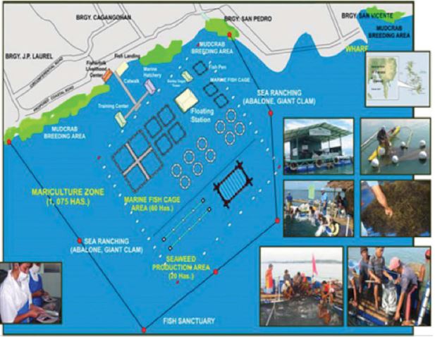
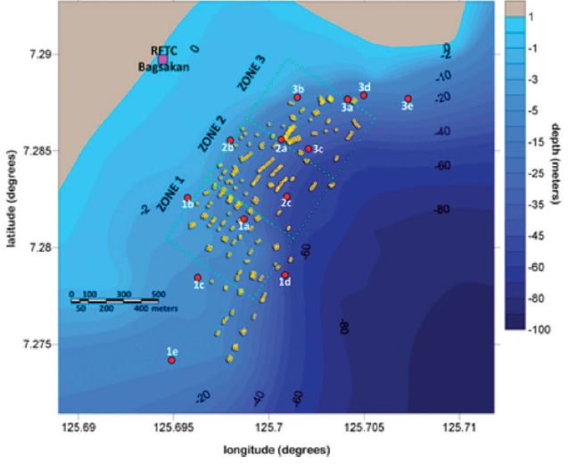
Establishment of boundaries for mariculture parks and the zonation plan is presented in Figures 4 and 5.
5. Public Consultation. Public consultation is undertaken in two phases, Pre-public hearings and Public hearings:
• Pre-public hearings. Initially there are prepublic hearings conducted with the attendance of the Mayor, Vice Mayor, Sangguniang Panlungsod (SB) Members, Non-Governmental Organisations (NGOs), and Chairmen of Coastal Barangays. Then a second pre-public hearing is conducted with the attendance of farmers and fishers, fishpond operators, hatchery operators, and input suppliers. Topics that are presented include:
• Overview of mariculture zone proposed development plan
• Business livelihood
• Opportunities to fishers
• Fishers/farmers obligations and benefits.
Figure 4. Initial mariculture plan and boundaries.
Following the pre-public meeting, the municipal ordinance or resolution is drafted, which reserves the identified area for the mariculture park.
• Full public hearing. This is followed by consultation comprising of a full public hearing.
6. Mariculture Park Operations Manual. Following the public hearing the Mariculture Park Operations Manual is prepared and adopted followed by drafting and approving a resolution authorizing the mayor to sign a Memorandum of Agreement (MoA). This MOA is between BFAR and LGU and states the function and obligations of BFAR as well as the function and obligations of LGU.
7. Environmental Compliance Certificate. An environmental compliance certificate (ECC) secured from the Environmental Management Bureau (EMB) of the Department of Environment and Natural Resources (DENR) is likewise required before the area is developed on a commercial scale. The TROPOMOD model is a tool that can support the Environmental Impact Assessment prior to ECC issuance
The process for fulfilling the environmental requirements is as follows:
• Survey and data gathering for the preparation of the EIA
• Compliance of ECC requirements
• Filing of ECC.
Figure 5. Panabo Mariculture Park with depth profile and spatial distribution of fish cages.

Note: Depth profiles are in shades of blue with indicated depth in meters at low tide, June 2011, and spatial distribution of 320 fish cages (yellow boxes), as of September 2010. Also indicated are 3 zones (delineated by dotted lines) used as reference divisions for the survey. Red dots indicate stations for water/substrate quality monitoring. Individual farm plot boundaries are distinguished by poles with coloured coded flags in all areas.
The conduction of an Environmental Impact Assessment (EIA) determines which area of the coastal municipality is to be declared as MP zones.
White (2009) described the process for EIA and environmental monitoring of clusters of smallscale farms in Bolinao.