2 Aquaculture Zoning
2.1 Definition of Ecosystem Boundaries (Spatial, Social and Political Scales)
Mariculture zoning was carried out in terms of a 2006 Environmental Law. In this mariculture zone aquaculture has precedence over other uses. It is recognized by physical and spatial planning authorities that a system aimed at integrating aquaculture activities into coastal zone areas should avoid conflicts with other users.
According to this law “Marine aquaculture facilities should not be constructed in sensitive areas such as enclosed bays and gulfs or in natural and archeologically protected areas.” In connection with this law, a Notification which describes criteria for aquaculture site selection (Table 1 and Table 2), in enclosed bays and gulfs was published in 2007 (MEF, 2007). According to a further amendment of this law, farms unable to fulfil these new criteria were compelled to relocate in the years between 2008–2009 (Figure 2). Fish farms found to be in contravention of this notice were under threat of closure. Since this Turkish legislation was enacted, the majority of fish cages have been moved further from the near-shore coast as required. The law further indicates that monitoring is necessary in fish farms, which already exist in enclosed bays and gulfs, if these sensitive areas have an eutrophication risk.
Ecological boundaries based on Posidonia oceanica (Table 1) and eutrophication (Table 2) are outlined in the tables.
An accurate definition of social boundaries is considered a key issue to ensure the sustainable development of aquaculture in Turkey. Pressures of coastline occupancy and use are increasing. The image of aquaculture has often had a negative reputation regarding the quality of product and impact of this activity on the environment. This boundary needs to be identified, analysed and integrated in the selection and management of aquaculture sites.
2.2 Consultation with Stakeholders
Coastal aquaculture along the Eastern Aegean coast has been going through a period of unprecedented growth over the past 15 years, especially along the Izmir and Mugla coasts. The rapid growth of fish farming and tourism has been paralleled by the very rapid urbanization of the coastal zone. Coastal planning was realized by the inter-ministry committee. This activity is vital for both aquaculture facilities and other stakeholders. The development of Turkish Marine Aquaculture site selection and zoning should address all the issues through a participatory process involving stakeholders, scientists and government. It is necessary to find acceptable solutions for site selection and zoning. Agreements must be negotiated on the most cost-effective and socially acceptable mechanism for mariculture development.
This is a frequently a weak point in the whole process.
Legal, Regulatory and Institutional Frameworks Finfish farmers must obtain permits from the Ministry of Food, Agriculture and Livestock (MFAL*). Finfish farming activities are controlled by a number of specific laws and regulations administered mainly through the MFAL and the Ministry of Environment and Urbanization (MEU**).
Table 3 shows Turkish laws and regulations about aquaculture.
*MARA changed to MFAL in 2011.
**MEF changed to MEU in 2001.
Table 3. Legal, regulatory and institutional frameworks.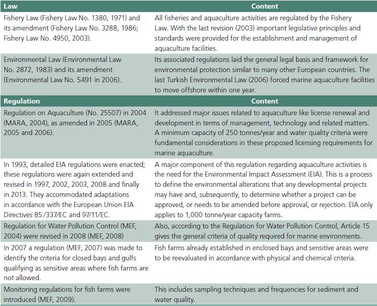
Licensing Requirements for Cage Farms and EI A Procedures
MFAL is the main authority responsible for licensing sea cage farms with a minimum capacity of 250 t per year (MARA, 2006). Figure 3 shows stages and durations associated with the steps of the licensing procedure.
Besides MFAL, a number of other public authorities are also involved in the licensing process. These include the Ministry of Health, the Ministry of the Environment and Urbanization, and Undersecretariat of Maritime Affairs which takes the responsibility of contacting the Ministry of Culture and Tourism. This procedure is only covering sea level, whereas land logistic activities are more challenging. Currently in Gulluk Bay, Mugla Fish Farmer’s Association is negotiating communal land access, facilities and piers.
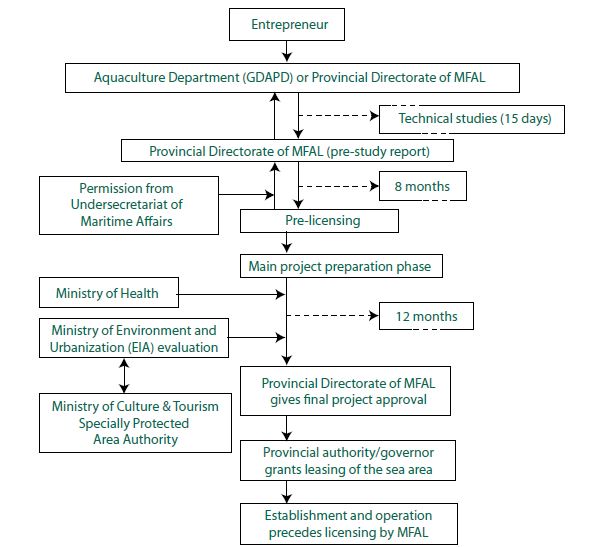
Figure 3. Site licensing and leasing procedures for marine fish farms.
According to the Aquaculture Regulation (MARA, 2004) the following requirements for marine cage fish farms should be given:
1. Space⁄area available on a license should be large enough to allow for site rotation and should be no less than twice the actual area occupied by the cages.
2. Distance between cage farms is determined by the
central Aquaculture Department according to criteria such as projected annual production capacity, water depth and current speed.
In Environmental Law No.5491, 2006 amendments, finfish farming in sensitive areas such as enclosed bays and natural or archaeological sites were prohibited.
Details of this ban were substantiated by a notification in 2007. Fish farms already established in enclosed bays and sensitive areas were to be reevaluated in accordance with the physical and chemical criteria indicated in the Tables 1 and 2.
EIA Procedures
A major component of this law (Table 3) regarding aquaculture activities is the need to execute an Environmental Impact Assessment (EIA), which is a process to define the environmental alterations that any developmental projects may have and, subsequently, to determine whether a project can be approved, or needs amending before approval, or must be rejected. MEU issues a special format for the EIA of a marine aquaculture farm, which defines the scope of the necessary investigations; a summary of this is given in Table 4.
In the context of the EIA regulations, it has also been pointed out that the international conventions for environmental protection ratified by the Turkish government should also be respected and considered within the EIA procedure. Those farms producing over 1,000 tonnes yearly have to prepare a full EIA report and those smaller than 1,000 tonnes per year are eligible for a preliminary EIA investigation.
Table 4. The special format used in an application for an EIA report in connection with the establishment of an aquaculture project (MEF, 2008).
Zone Management of Gulluk Bay
Two mariculture zones were defined in Gulluk Bay, Mugla. There was a Milas Zone and a Bodrum Zone as defined by a Turkish Inter-Ministerial Consortium, together with the Mugla Fish Farmers Association. We had Regional Environmental Impact Assessment studies for these two zones from the Ministry of Environment.
The following points are specified in the EIA in order to assist the management process:
• The cage-net can only occupy a maximum of 1⁄3 of the water column.
• Eighty-one fish farms are to be established in 50 parcels with a capacity between 300 tonnes to 3,000 tonnes. In each parcel there can be 2 to 4 fish farms.
• Distance between the parcels should be a minimum of 400 m to a maximum 5.6 km.
• The area of parcels should be between 8,400 m2 to 92,500 m2. A maximum of four farms can share the same parcel.
• Fish farms in the same parcel will share the common responsibility of business agreements, according to which they have to take necessary precautions to avoid pollution. If pollution is detected and the source is not defined, all fish farms in the parcel will be held responsible.
• The fish farms within the common area (each parcel), should operate in harmony and within the assigned area. Thus the cages cannot be moved or expanded in an area without the permission of the ministries.
• The mooring systems to be established, together with their maintenance and checks, within the common area should be done in collaboration.
• Warning signalization to limit and identify the positioning of cages must be constructed. This is for
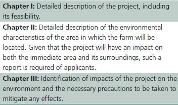
Figure 4. A barge near a fish farm in Gulluk Bay, Mugla.
labelling and providing a guard for safety of life and property. Marine traffic operators should be involved in this.
• Within this EIA there was no allowance for land logistics. All activities including social needs of personnel, food storages and automatic feeding machines should be constructed on barges (Figure 4).
These points are important for the management of the zone. But, unfortunately, the boundaries of each parcel within the zone and farms within each parcel are not properly defined for the purposes of management.
Therefore the cumulative effect of individual elements cannot be identified and rectified.
The Monitoring
Mugla Fish Farmers Association uses accredited laboratories to analyse the TRIX index twice a year, for all fish farms in the two allocated zones. All data is sent to the Ministry of Food, Agriculture and Livestock and to the Ministry of the Environment. According to monitoring regulations, labs must sample the water at surface level, in the water column and in the benthic zone including sediment for analysis. But there is no holistic thinking on environmental management at the Bay level. Our project called “Project for the Establishment and Development of Environmentally Sustainable Eco-Friendly Fish Farming Systems in the Aegean Sea 2014–2015” is piloting this process. But it needs to be upgraded and formalized.
Health monitoring is done by the MFAL for each farm.
But the requirements at parcel and zoning levels need more precise definition. Whereas some big companies use a very effective monitoring system along the lines of certificates like GLOBAL GAP, BRC, ISO 22000, ISO 14001, ISO 9001, HACCP, and IFS, unfortunately small farmers often fail to do this. Some farmers follow certification schemes but there is currently no generally used compulsory Code of Practice.
The two mariculture zones were evaluated separately in Gulluk Bay (Figure 2). An appropriate Environmental Impact Assessment (EIA) was performed at the time of the establishment of these aquaculture zones (EIA, 2008).
2.3 Zoning Process
2.3.1 Choosing the Tools for Spatial Planning
The general ICZM (Integrated Coastal Zone Management) rules propose that all required monitoring and analysis procedures must be implemented to identify the natural and human-induced stresses on the marine environment, and to resolve potential conflicts of interest.
In order to realize this goal, before executing any action, suitable, practical and reliable indicators should be determined. In terms of environmental analysis and evaluation, Geographic Information Systems (GIS) is a very useful tool, not only for capturing, storing, organizing, displaying and reporting of information but also for analyzing and modeling of spatial data (Kapetsky and Aguilar-Manjarrez, 2007). Some difficulties in data sharing among the related disciplines or institutions to develop the full potential of GIS have been challenging.
The spatial analysis of the mariculture zone Gulluk Bay has been completed (Yucel-Gier et al., 2013) and sent to the corresponding ministries.
2.3.2 Estimation of Aquaculture Potential
There have been several studies of the selection of areas for suitable fish farming in Turkey. Legislation has put a stop to fish farming activities in the gulfs and bays of Izmir and Mugla. Potential area studies for fish farm location were conducted at the administrative level and in coordination with other ministries in 2008. First, a subdepartment of the Ministry of Food, Agriculture and Livestock (MFAL), the Aquaculture Department of the Directorate General for Fisheries and Aquaculture, identifies drafts of potential aquaculture zones. It uses its own experts and researchers, paying attention to concerns of all other coastal sectors and users. It is the main authority for all aquaculture activities.
The Ministry has to map all identified zones and send the results to all related ministries and institutions, in order to obtain their opinions. These ministries reply to MFAL giving their opinions. MFAL then organizes some field trips and invites the related ministries to participate. A commission of experts and administrators representing all ministries and including local representatives of ministries and fish farmers visits the identified potential zones. They meet several times to discuss and achieve a consensus to determine the final potential zones for aquaculture. They also prepare a report on the decisions taken. The Undersecretaries of MFAL, the Ministry of Environment and other related ministries then sign a Protocol on the agreed zones.
After the field visits, MFAL sends a final version of potential zones to the Ministries to have their final say. The Official Gazette then publishes these zones as “Allocated Zones for Aquaculture” and distributes this information. For example for Gulluk Bay this process took six months. The Ministry then requires that the AZA for Gulluk Bay makes an EIA study. Other stakeholders are to be involved in this process. For example the Karaburun peninsula (Izmir) was originally selected (Figure 5). As long as area A is inside Izmir Bay it is identified based on criteria listed in Tables 1 and 2, and as areas B and C are outside the bay, there are no conflicts in the administrative level. In time the studies about monk seal existence were brought to daylight, so A and B were canceled. However new criteria and formulations for carrying capacity are now being researched IMST-216, 2013.