3 Zoning
3.1 Definition of Boundaries
Boundaries to define boundaries for aquaculture zoning in Uganda have not yet been defined so far.
The identification of areas with high potential for aquaculture has so far been based on information that could easily be obtained from secondary literature and participatory rapid site appraisals. Broadly, zones had to be based on criteria defined by MAAIF (2013) such as:
i. Political Boundary. Sites for both land and waterbased aquaculture had to be within the jurisdiction of Uganda.
ii. Water Management Zone. Areas with adequate year round water supply of suitable quality. Hence internal zonal boundaries cut across political district boundaries.
3.2 Assessment for Aquaculture Potential
3.2.1 Identification of Areas Suitable for Fish Pond Culture
Uganda has the potential to support commercial aquaculture. A continental assessment on fish farming potential in Africa by Aguilar-Manjarrez and Nath (1998) indicates Uganda has favorable conditions for aquaculture.
This was largely attributed to Uganda’s water resources and climate. Eighteen percent of Uganda is covered by water and its average precipitation is about 1,000 million per annum. Ambient temperatures range between 16–30oC. In addition, because Uganda lies along the equator, air temperature and day-length fluctuations are low permitting year round fish growth.
Uganda’s freshwater resources are suitable for cage, pond and tank based aquaculture systems. Its agricultural and fisheries sector produce all the raw materials required to make commercial fish feeds, except for some of the micro ingredients such as mineral and vitamin premixes. The country already makes commercial extruded fish feed. The species of choice for commercial aquaculture, the Nile tilapia (Oreochromis nilotics) and African catfish (Clarias gariepinus) are indigenous to the country. They are fast growing and have been proven under local commercial production settings (EU/MAAIF, 2011).
Uganda’s local and external market potential for fish is also good. Uganda is traditionally a fish eating country.
The country also has established marketing channels for fish that it cannot satisfy within the region and internationally. A well-developed fish processing sector that is underutilized due to inadequate supply of raw fish is in place. Increased fish production from aquaculture would benefit from the already present fish processing infrastructure.
Information from previous assessments (MAAIF, 2013) and Ssegane, Tollner and Veverica (2012) were used to evaluate the potential for pond aquaculture.
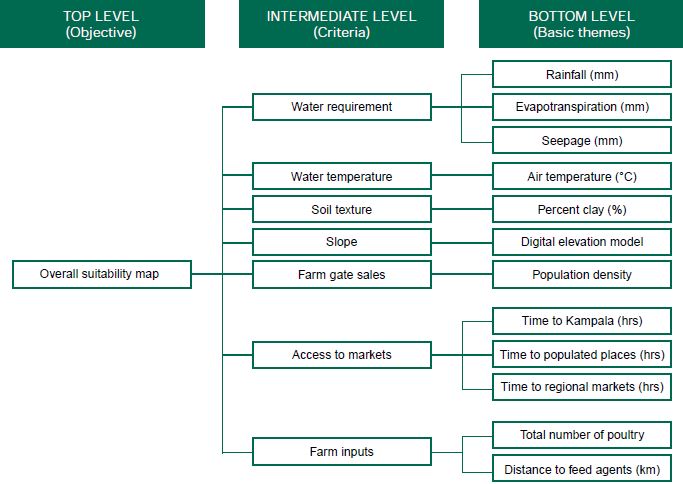
Ssegane, Tollner and Veverica (2012) provides a comprehensive spatial assessment for the potential of pond-based aquaculture in Uganda. Seven criteria (water requirement, water temperature, soil texture, terrain slope, potential farm gate sales, availability of farm inputs, and access to local and regional markets) were analyzed by Ssegane, Tollner and Veverica (2012) to determine site suitability for tilapia and clarias farming in Uganda. Figure 3 depicts the seven criteria used to assess site suitability for fish farming. For each criterion, the corresponding data requirements were defined as basic map themes.
Figure 3. Criteria used in geospatial modelling of sites suitable for pond fish farming in Uganda.

Source: Ssegane, Tollner and Veverica (2012).
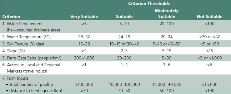
Based on suitability thresholds, each criteria was classified into four suitability groups across the seven criteria (Table 4). The groups Include Very Suitable (VS), Suitable (S), Moderate Suitability (MS), and not Suitable or Unsuitable (NS).
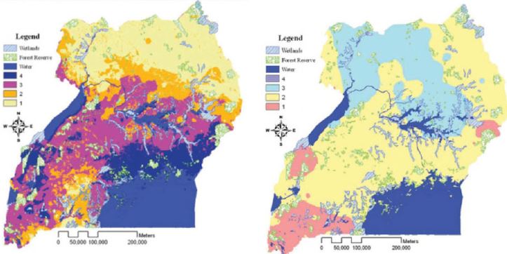
The study by Ssegane, Tollner and Veverica (2012) revealed the areas around Lakes Victoria and Kyoga as being most suitable for pond aquaculture (Figure 4).
The least suitable areas for pond production were the northeast and southwestern parts of the country due to prolonged dry spells and low temperatures respectively.
Additional maps representing soil texture; percent slope, farm gate sales; access to markets; and access
Table 4. Summary of values for each suitability group across the seven criteria.

Source: Ssegane, Tollner and Veverica (2012)
Figure 4. Fish pond farming suitability maps based on water availability and water temperature.
to farm inputs were analyzed by Ssegane, Tollner and Veverica (2012). The final results after combining all criteria showed that 0.09 percent (16,322 hectares) of the land area in Uganda was very suitable. More than 98 percent of the area was classified as suitable or moderately suitable; however, the distributions of the suitability values on each map varied. The very suitable locations are areas near Lake Victoria, while the unsuitable locations are areas in the northeast and southwest of the country. The northeast areas are characterized by dry periods, while the southwest areas experience low temperatures.
3.2.2 Identification of Areas Suitable for Aquaculture Parks
Assessments by the National Fisheries Research Institute (NaFIRRI) to identify potential zones for Aquaculture Parks within areas identified as having high potential for aquaculture by Ssegane, Tollner and Veverica (2012) were mainly qualitative comprising of rapid site appraisals, stakeholder consultations and analysis of secondary information. Inter-disciplinary teams comprising personnel from the fisheries department, other arms of MAAIF, Directorate of Water Development, local government departments, and the private sector formed the sited evaluation teams. Consultations were undertaken between and within line departments, local communities, district administrators, and community based organizations (notably Beach Management Units, farmer groups) as well as ordinary people living within the communities from all sectors of life and security agencies. The above processes additionally served to verify secondary information and assess public opinion. Consultations with local communities revealed a lot of important information about the ecosystems that had not been documented. For example, seasonality of water sources, migration routes of wild animals including aquatic animals, incidences and cycles of fish kills in certain areas of lakes, wave characteristics and so on.
Specific studies were also commissioned in which local aquaculture production, environmental and market data were obtained with the objective of validating assumptions proposed in the “Aquaculture Parks” concept. This enabled the planners and stakeholders to re-adjust production targets more realistically in tandem with local constraints. The process has helped create more positive public attitudes towards the Aquaculture Parks concept, particularly for the waterbased parks where public skepticism was initially high.